-
Shipping Details
U.S. Domestic
Flat Rate Shipping
$3.50 per order (Standard)
$10.50 per order (Expedited)
International Shipping
You pay actual shipping cost.
No additional fees.
If the cost is higher than the estimate shown at checkout we will email you for approval before we charge your card.
Wholesale Customers
You pay actual shipping cost.
No additional fees. Actual cost is determined when your order is packed for shipment. -
Prefer to order by phone?
Order this product online or by phone
Call us now at (707) 822-9063
Mon-Friday 8am to 5pm PST
Description
• Waterproof
• Tear-Resistant
• Topographic Maps
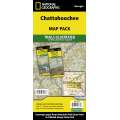
National Geographic's Chattahoochee Bundle Pack combines two Trails Illustrated titles for Chattahoochee National Forest. Located just north of Atlanta, the Chattahoochee National Forest contains the southern terminus of the Appalachian Trail along with an abundance of recreational opportunities for outdoor enthusiasts of all interests. The maps' highlights are: Southern Terminus of the Appalachian Trail, Russell-Brasstown Scenic Byway, Cohutta, Raven Cliffs and Rich Mountain Wilderness Areas, White Rock Scenic Area, Brasstown, Ellicot Rock, Southern Nantahala, Tray Mountain, Raven Cliffs Wilderness Areas, and Chattooga Wild and Scenic River.The Chattahoochee National Forest Map Pack includes: Map 777 :: Springer and Cohutta Mountains [Chattahoochee National Forest] Map 778 :: Brasstown Bald, Chattooga River [Chattahoochee and Sumter National Forests]
Every Trails Illustrated map is printed on "Backcountry Tough" waterproof, tear-resistant paper. A full UTM grid is printed on the map to aid with GPS navigation. Map Scale = 1:70,000 Sheet Size = 37.75" x 25.5" Folded Size = 4.25" x 9.25"
Details
Specifications
Reviews
No reviews found


