

-
Shipping Details
 U.S. Domestic
Flat Rate Shipping
$3.50 per order (Standard)
$10.50 per order (Expedited)
 International Shipping
You pay actual shipping cost.
No additional fees.
If the cost is higher than the estimate shown at checkout we will email you for approval before we charge your card.
 Wholesale Customers
You pay actual shipping cost.
No additional fees. Actual cost is determined when your order is packed for shipment. -
Prefer to order by phone?
Order this product online or by phone
Call us now at (707) 822-9063
Mon-Friday 8am to 5pm PST

Description
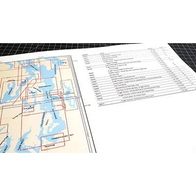
Over 50 reduced-scale complete NOAA charts of the Chesapeake Bay and surrounding area. Spiral-bound in a large format (12x18") booklet. Printed on high-quality paper and updated regularly.
Not recommended for navigation, but handy for reference and planning.
Each chart atlas includes a map key at the beginning which helps you locate the charts inside.
- Charts are organized numerically by chart number
- Easy-to-read map grid clearly indicates each chart's area of coverage
Includes the following NOAA charts:
- 12205
- 12206
- 12207
- 12208
- 12210
- 12211
- 12216
- 12221
- 12222
- 12224
- 12225
- 12226
- 12228
- 12230
- 12231
- 12233
- 12235
- 12237
- 12238
- 12241
- 12243
- 12244
- 12245
- 12248
- 12251
- 12252
- 12253
- 12254
- 12255
- 12256
- 12261
- 12263
- 12264
- 12266
- 12268
- 12270
- 12272
- 12273
- 12274
- 12277
- 12278
- 12280
- 12281
- 12282
- 12283
- 12284
- 12285
- 12286
- 12287
- 12288
- 12289
Details
Specifications
Reviews
No reviews found