Filter Search Results

Use the CHS Chart Index

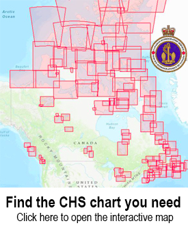
Displays the geographical extent of products produced by the Canadian Hydrographic Service,
Canadian Hydrographic Charts

The Canadian Hydrographic Service distributes nautical charts for navigation through a dealer network that serves Canada and the entire world. These are paper charts covering all 3 of Canada’s coastlines plus major lakes and inland waterways.


You will need the number of your chart when ordering.

To find the chart that you need, you can search the chart catalogs or interactive maps.

  • Chart Index – an interactive web map showing both digital and paper chart coverage areas
  • List of Charts – Paper charts
$24.95
CAN7171
Paper Chart
$24.95
CAN4118
Paper Chart
$24.95
CAN5469
Paper Chart
$24.95
CAN3977
Paper Chart
$24.95
CAN6110
Paper Chart
$24.95
CAN3536
Paper Chart
$18.95
CAN3651
Paper Chart
$24.95
CAN7135
Paper Chart
$24.95
CAN6036
Paper Chart
$24.95
CAN3859
Paper Chart
$24.95
CAN4848
Paper Chart
$48.95
CAN6100
Paper Chart, 2 charts @ 36x 57
$24.95
CAN5351
Paper Chart
$24.95
CAN3646
Paper Chart