Filter Search Results

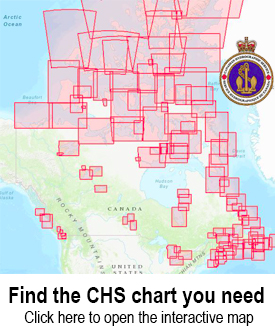
Use the CHS Chart Index

Displays the geographical extent of products produced by the Canadian Hydrographic Service,
Canadian Hydrographic Charts

The Canadian Hydrographic Service distributes nautical charts for navigation through a dealer network that serves Canada and the entire world. These are paper charts covering all 3 of Canada’s coastlines plus major lakes and inland waterways.


You will need the number of your chart when ordering.

To find the chart that you need, you can search the chart catalogs or interactive maps.

  • Chart Index – an interactive web map showing both digital and paper chart coverage areas
  • List of Charts – Paper charts
1 2 3 4 5 6
CHS Chart 4170: Glace Bay Harbour
CAN4170

$24.95
CHS Chart 4266: Sydney Harbour
CAN4266

$24.95
CHS Chart 4275: St. Peters Bay
CAN4275

$24.95
CHS Chart 4276: Little Bras D'or
CAN4276

$24.95
CHS Chart 4279: Bras D'Or Lake
CAN4279

$24.95
CHS Chart 4340: Grand Manan
CAN4340

$24.95
CHS Chart 4379: Liverpool Harbour
CAN4379

$24.95
CHS Chart 4381: Mahone Bay
CAN4381

$24.95
CHS Chart 4396: Annapolis Basin
CAN4396

$24.95
CHS Chart 4402: Wallace Harbour
CAN4402

$18.95
CHS Chart 4416: Havre de Gaspé
CAN4416

$24.95
CHS Chart 4450: St. Paul Island
CAN4450

$18.95
CHS Chart 4462: St. George's Bay
CAN4462

$24.95
CHS Chart 4466: Hillsborough Bay
CAN4466

$24.95
CHS Chart 4483: Caribou Harbour
CAN4483

$24.95
CHS Chart 4491: Malpeque Bay
CAN4491

$24.95
CHS Chart 4492: Cascumpeque Bay
CAN4492

$24.95
CHS Chart 4497: Amet Sound
CAN4497

$24.95
CHS Chart 4509: Pistolet Bay
CAN4509

$24.95
CHS Chart 4511: Sacred Bay
CAN4511

$24.95
CHS Chart 4515: Hare Bay
CAN4515

$24.95
CHS Chart 4518: Ariege Bay
CAN4518

$24.95
CHS Chart 4521: Baie Verte
CAN4521

$24.95
CHS Chart 4541: Sops Arm
CAN4541

$18.95
CHS Chart 4542: Hampden Bay
CAN4542

$18.95
CHS Chart 4587: Mortier Bay
CAN4587

$24.95
1 2 3 4 5 6